|
We are located in the foot hills on the eastern side of the Blue Ridge
Mountains of Virginia.
We have pets regularly visiting us from DC, Maryland and throughout Virginia.
If
you like to ride in the country you will enjoy the drive.
Your pets will appreciate you going the distance.
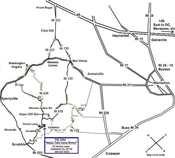
It is hard to find our small town on the map but if you draw a triangle between Sperryville, Warrenton and Culpeper
we are located towards the center and about a half hour drive from these three towns.
Because this is also our
home and a working farm we do not welcome walk-ins, Please call ahead for an appointment at (540) 937-5542
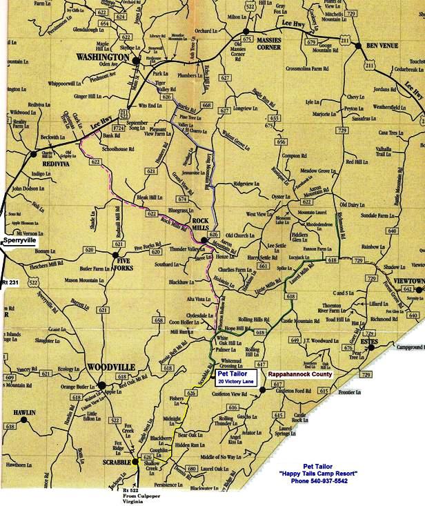
* Our Address is 20 Victory Lane Castleton, Va 22716
It is best to follow the directions
below because Cell Phones and GPS
do not always work well here
|
|
|
Directions
Do watch the mileage as listed below because you will feel like you have missed us when you have not
gone far enough. It is a pretty drive and easier than it may sound your first time out.
From Fredericksburg
Take Rout 3 West From
Fredericksburg to Culpeper and follow Culpeper directions.
From Culpeper
Take Route 522 North towards Sperryville. After you pass Blackwater creek but before you get to a town called Woodville. At Scrabble, turn right on Scrabble Road also known as Route 626. Stay as stright as you can
and don't turn on gravel roads. We are 3 point 1 miles on your right. You will see The Pet Tailor sign on Scrabble
Road and the Victory Lane sign. Follow the Pet Tailor signs down the driveway to our office.
From Madison
Take route 231 North towards Sperryville and turn right onto Route 522 South and
follow Sperryville directions.
From Sperryville
Take Route
522 South past Woodville and look on your Left for the Mount Lebanon church sign at Scrabble. Turn left on Scrabble Road also
called Route 626. Stay as stright as you can and do not turn on gravel roads. We are 3 point 1 miles down on the right. You
will see The Pet Tailor sign on Scrabble Road and Victory Lane sign. Follow the Pet Tailor signs down the driveway to our
office.
From Amissville
From Route 211, turn
onto Route 642. Stay on this road for 5 Miles all the way to the stop sign. Turn right onto Route 729, go a mile
down the road and continue straight onto route 618. Go 2 point 9 miles and turn right onto Hope Hill Road - also still Rt
618 at this point. (If you like to count roads it will be the second State Road to your right) Once you turn, go as straight
as you can for a winding country road. The route numbers and the road names will change but do not make any more turns, we
are exactly 2 point 2 miles on your left. You will see The Pet Tailor sign and Victory Lane sign. Follow the Pet Tailor signs
down the driveway to our office.
From Front Royal
Take Route
522 South to Flint Hill. Turn Left onto route 729 and cross route 211 at Ben Venue. Go 5 Miles to the stop sign and turn
Right onto Route 618. Go 2 point 9 miles and turn right on Hope Hill Road. Go as stright as you can for 2 point 2 miles and
don't turn onto gravel roads. Make a left turn by the Victory Lane sign and follow Pet Tailor signs to the office.
From Washington DC
Take interstate 66 West, past Manassas and exit at the
Gainesville Route 29 South exit and go South towards Warrenton. Take the first exit to Warrenton and Luray. Turn right onto
Route 211 West. Now follow directions from Warrenton.
From Warrenton
Take Route 211 West to Amissville and turn left on Route 642. Stay
on this road for 5 Miles all the way to the stop sign. Turn right onto Route 729, go a mile down the road and continue
straight getting off of route 729 and onto route 618. Go 2 point 9 miles and turn right onto Hope Hill Road - still Rt
618 at this point. (If you like to count roads it will be the second State Road to your right) Once you turn, go as straight
as you can for a winding country road. The route numbers and the road names will change but do not make any more turns, we
are exactly 2 point 2 miles on your left. You will see The Pet Tailor sign and Victory Lane sign. Follow the Pet Tailor signs
down the driveway to our office.
From Jeffersonton
From
Jeffersonton’s Ma and Pa Store on route 229-take route 640 beside the store. You have two choices of how to go.
If you do not want to use a gravel road go all the way down and turn right on route 729. Go straight onto route 618
where route 729 takes a sharp right turn towards Ben Venue. Look at your mileage and go 2 point 9 miles and turn right. (If
you like to count roads it will be the second State Road to your right) The Road you will be turning onto is called Hope Hill
Road but is also still route 618 at this point. Once you turn, go as straight as you can for a winding country road. The Route
numbers and the Road names will change but do not make any more turns, we are exactly 2 point 2 miles on your left. You will
see The Pet Tailor sign and Victory Lane sign. Follow the Pet Tailor signs down the driveway to the office.
OR Plan B
For the adventurous or those that don’t mind gravel roads, from route 640 you can
turn right on Doc’s Road, at the stop sign turn left onto route 642, at the next stop sign, turn right on route 729
and go straight onto route 618 at the bottom of the hill where 729 makes a right turn and go straight getting onto route 618.
Look at your mileage and go 2 point 9 miles and turn right. (If you like to count roads it will be the second State Road to
your right) The Road you will be turning onto is Hope Hill Road and is still Route 618 at this point. Once you turn, go as
straight as you can for a winding country road. The Route numbers and the Road names will change but do not make any more
turns, we are exactly 2 point 2 miles on your left. You will see The Pet Tailor sign and Victory Lane sign. Follow the signs
down the driveway to the office.
_________________________________________________
"If" you
find the bridge Flooded in Laurel Mills area on Route 618 by Route 729
Take Route 729 also known
as Richmond Highway South towards Culpeper.
Turn Right onto Castleton Ford Road. Go to the "T" intersection
and stop sign; turn right onto Castleton View Road. Take the next left onto Hope Hill Rd. We are 2 point 2 miles on left.
You will see The Pet Tailor sign and Victory Lane sign.
|
|
|